For more than two centuries, the urban origins of Paris have been wrapped in a fiercely contested historical mystery. While Julius Caesar famously documented the existence of Lutetia—the fortified island stronghold of the Parisii Celtic tribe—in his war memoirs, generations of modern archaeologists failed to find any tangible trace of an Iron Age oppidum beneath the historic core of the Île de la Cité. That long-standing conundrum has now come to a dramatic and definitive end.
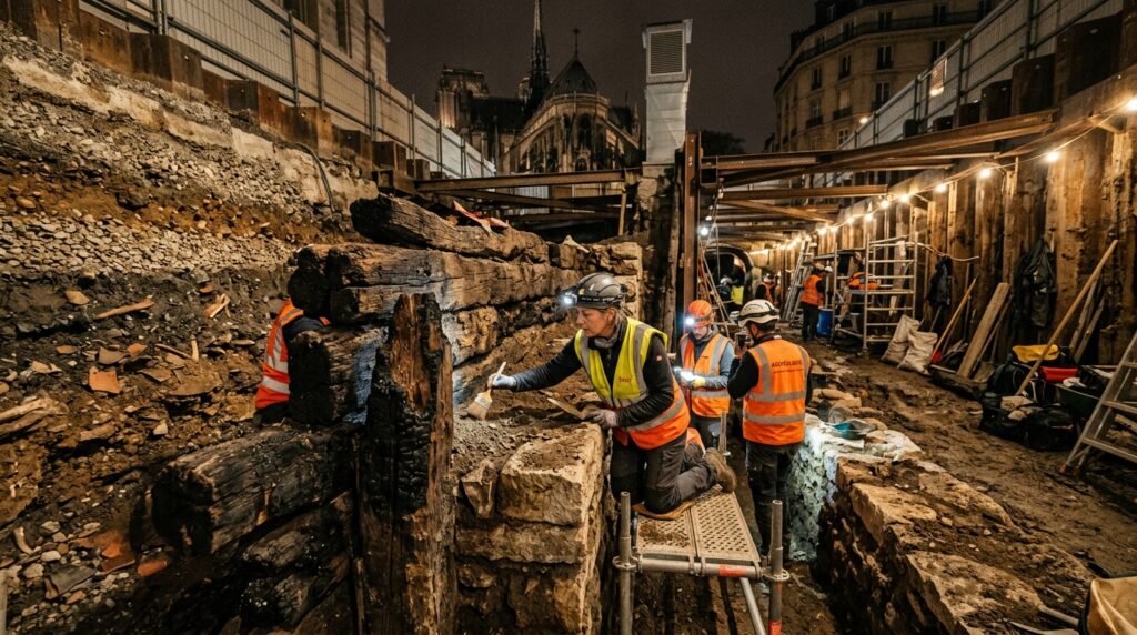
Deep beneath the cobblestones of the Île de la Cité, just footsteps from the flying buttresses of Notre-Dame Cathedral, preventive archaeologists from the French National Institute for Preventive Archaeological Research (Inrap) and the City of Paris have uncovered the physical remnants of an extraordinary defensive structure: a 20-meter-long rampart composed of massive stone blocks and crisscrossed oak timbers, bearing the unmistakable, violent black scorch marks of an ancient inferno. Accompanied by charred agricultural grain, collapsed architectural debris, and an iron Gallic spearhead, the discovery aligns with astonishing precision to a pivotal moment recorded over 2,000 years ago in Book VII of Caesar’s Commentarii de Bello Gallico: the intentional burning of Lutetia in the summer of 52 BCE.
The Phantom Oppidum: The Century-Long Debate Over Paris’s Cradle
To grasp why this discovery has reverberated across the archaeological world, one must understand the frustrating historiographical puzzle that has haunted Parisian archaeology since the 19th century. According to Roman historical literature, when Julius Caesar mounted his military campaign against the Gallic coalitions led by Vercingetorix in 52 BCE, Lutetia was described as an oppidum—a fortified Celtic proto-city—located strategically upon an island in the middle of the River Seine (Sequana).
Yet as modern Paris underwent massive civil engineering projects, subterranean metro expansions, and basement renovations throughout the 20th century, archaeologists consistently uncovered Roman ruins dating from the 1st to 4th centuries CE—including the famous Roman baths of Cluny and the Arènes de Lutèce amphitheater—but virtually nothing belonging to an indigenous Gallic settlement on the Île de la Cité.
This baffling absence led to intense academic polarization:
- The Traditionalist School: Maintained that the continuous two-millennium occupation of the Île de la Cité had simply erased or pulverized earlier Gallic wooden and earthen fortifications.
- The Nanterre Hypothesis: Gained immense traction in the early 2000s when massive archaeological excavations in the western suburb of Nanterre unearthed a sprawling, 15-hectare Late Iron Age Celtic settlement complete with organized streets, elite residences, and craft quarters. Many prominent prehistorians argued that Nanterre was the “real” Lutetia of Caesar, relegating the Île de la Cité to a minor Roman secondary outpost.
“For decades, we carried the uncomfortable paradox of a foundational national history that existed vividly on Roman parchment, yet seemed entirely absent from the subterranean strata of Paris itself. This discovery closes that gap with physical fire and timber.”
— Senior Research Archaeologist, Inrap Mission Île de la Cité
Beneath the Hôtel-Dieu: Anatomy of an Iron Age Bastion
The breakthrough unfolded during extensive rescue archaeological excavations conducted beneath the historic Hôtel-Dieu hospital complex, Paris’s oldest healthcare institution originally founded in the 7th century. Undertaken ahead of major structural restoration work, excavators dug through centuries of medieval foundations, Merovingian cemetery layers, and Roman domestic mortar until they reached natural river deposits more than four meters below the modern street surface.
There, embedded within the water-saturated alluvium of the ancient Seine, the team identified an imposing defensive bastion that altered everything:
- A 20-Meter Monumental Rampart: Excavators cleared a continuous 20-meter (65-foot) stretch of defensive fortification built using traditional Celtic civil engineering principles. The structure integrates dressed limestone ashlar blocks reinforced by heavy horizontal oak tie-beams (poutres armées), a construction method conceptually allied to the classical murus gallicus described across continental Europe.
- Artificial Ground Elevation: Abutting the timber-framed stone barrier, archaeologists uncovered a massive, two-meter-thick artificial earthen platform constructed from compacted gravel, river silts, and sand. This monumental platform was engineered by Gallic builders to elevate the settlement’s core safely above the seasonal flood crests of the Seine.
- Trench Weaponry and Artifacts: Lodged directly at the exterior base of the rampart, researchers recovered a well-preserved forged iron Gallic spearhead (lancea), indigenous Late La Tène ceramics, and personal ornaments discarded during defensive operations.
Summer 52 BCE: Reading Caesar’s War Chronicles in the Soil
What elevates this excavation from an important structural find into a world-class historical milestone is the overwhelming evidence of catastrophic destruction. The oak timbers framing the wall do not show signs of gradual decay or seasonal rotting; they are heavily carbonized, reduced to dense charcoal by temperatures exceeding 800 degrees Celsius.
Intertwined with the charred timber beams are thick destruction strata filled with blackened baked daub, burnt thatched reed roof fragments, and dense caches of carbonized cereal grains (spelt and barley). Preliminary radiocarbon analysis conducted using Accelerator Mass Spectrometry (AMS) on the outermost tree rings dates the timber felling and conflagration to between 200 BCE and 10 BCE—a narrow chronological envelope that squarely captures the fateful events of 52 BCE.
Historical Chronicle: The Battle of Lutetia
In Chapter 57 of Book VII of the Gallic Wars, Caesar recounts sending his most trusted military lieutenant, Titus Labienus, north with four Roman legions to subdue the Parisii and Senones. The Gallic forces rallied under the leadership of Camulogenus, an aged but revered Aulercian general. When Labienus attempted to outmaneuver the Gauls by traversing the marshlands of the Seine, Camulogenus executed a desperate, tactical scorched-earth withdrawal:
“The enemy, having perceived what was done by the scouts, order Lutetia to be set on fire, and the bridges of that town to be broken down; and they themselves advance from the woods, and take a position on the banks of the Seine, over against the camp of Labienus.”
For more than two millennia, historians debated whether Caesar’s chronicle was military propaganda designed to dramatize the campaign or an accurate report of tactical self-immolation. The conflagration layer unearthed at the Hôtel-Dieu provides unvarnished, physical confirmation: the Parisii set their own island stronghold ablaze to deny its granaries, docks, and defensive ramparts to the advancing legions of Rome.
Scientific Multi-Proxy Dating: Precision Chronology
To establish an unassailable scientific foundation for the find, French archaeological laboratories deployed a rigorous multi-proxy analytical protocol:
- Dendrochronological Profiling: Dendroarchaeologists extracted cross-sectional cores from the least damaged interior segments of the waterlogged oak beams. By matching tree-ring growth sequences against master European oak chronologies, researchers are working to pinpoint the exact decade the trees were felled.
- Archaeobotanical Flotation: Analysis of the charred seed deposits revealed domesticated emmer, barley, and lentil varieties typical of late Celtic agricultural storage, proving the site was an active civic and logistics depot at the moment of burning.
- Stratigraphic Pedology: Soil micromorphology confirmed that immediately following the high-intensity fire, the site experienced a brief hiatus before being systematically leveled by early Roman legionary engineers, who deposited a thick gravel leveling layer upon which the first Romanized stone street network was constructed.
Rewriting the Story of Paris and European Urbanism
The discovery of the burned ramparts beneath the Île de la Cité redefines the civilizational narrative of one of the world’s most iconic capitals. It resolves the long-standing debate with Nanterre by illustrating that the Parisii possessed a multi-nodal territorial organization: while Nanterre served as an expansive commercial and industrial trading hub along the wider river bend, the Île de la Cité served as the fortified political citadel, religious sanctuary, and river-crossing stronghold—the authentic heartbeat of the ancient tribe.
Furthermore, the find honors the tenacity of urban rescue archaeology. In an ultra-dense, continuously inhabited metropolis like Paris, where every square meter has been reshaped by Roman builders, medieval monks, Haussmannian boulevard planners, and modern transit engineers, the past is never entirely lost. It waits quietly in the deep, water-cooled sediments beneath our feet, ready to validate the voices of antiquity and remind us that beneath the City of Light lies an indomitable foundation forged in stone, timber, and flame.